Mon, 08/16/2010 - 17:10
Social Sharing block
Body
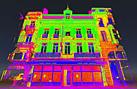 (Pointools: Barnet, UK) -- A high-tech digital map created with laser-scanning technology is underway for the Flanders region of Belgium. Using Pointools’ 3-D mapping software, the Belgian surveying company, Teccon, has processed billions of individual measurements to create high-accuracy data for use by Belgium’s central and regional government, plus utility companies and the transport sector. A combination of surveying techniques including mobile laser mapping, satellite navigation, and more traditional field and office data capture methodologies, has resulted in an attributed base map that now covers more than 1,200 square kilometers.
…
Want to continue?
Log in or create a FREE account.
By logging in you agree to receive communication from Quality Digest.
Privacy Policy.
Add new comment